Perception Kits · Autonomy & Field Robot Kit
HyperEdge 900DR – Highway Autonomy Advanced Sensor Fusion Kit
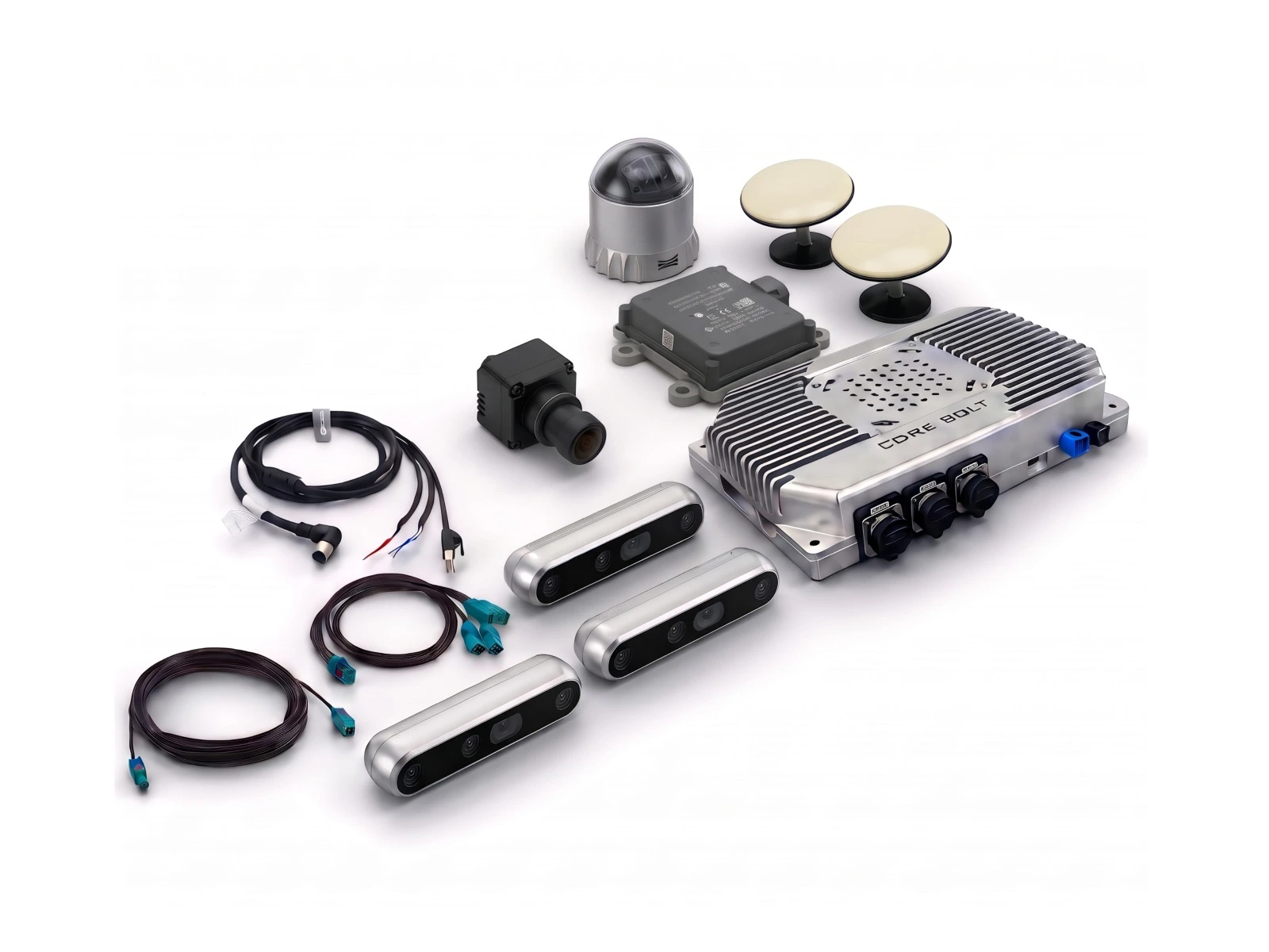
The HyperEdge 900DR Highway Autonomy Advanced Perception Kit is a multi-sensor hardware platform for autonomous vehicle and long-haul vehicle development. It combines CORE BOLT's dual-processor HyperEdge 900DRV Edge AI Computer with 3D LiDAR, a Continental ARS 408-21 77 GHz radar, an RTK M20X GNSS/INS receiver and an 8 MP GMSL2 automotive camera, giving sensor-fusion teams LiDAR, radar, camera and positioning data on one validated platform.
Specifications
- System Configuration
- HyperEdge 900DRV — AI Edge Computer
- HyperEdge 900DRV — Interfaces & Environment
- Ouster OS1 Rev8 — 3D LiDAR
- Ouster OSDome Rev8 — 3D LiDAR(Optional)
- Livox Mid-360S — 3D LiDAR (Option)
- [8mp]-sg8-isx028c-g2g — Gmsl2
- RealSense™ Depth Camera D455(Optional)
- Continental ARS 408-21
- RTK M20X GNSS/INS - mushroom antenna
- Integration & Connectivity
- Deployment Notes
Specifications
Technical Specifications
HyperEdge 900DR — Highway Autonomy Kit (Advanced) — System Configuration
| Parameter | Specification |
|---|---|
| Product Type | Integrated AI Perception Kit |
| Kit Code | CB-SHU-1310 |
| Primary Compute | CoreBolt HyperEdge 900DRV |
| Compute Configuration | NVIDIA Jetson AGX Orin 32GB or 64GB + TI TDA4VM |
| Maximum AI Performance | Up to 208 TOPS (AGX Orin 32GB) or 275 TOPS (AGX Orin 64GB), plus TI TDA4VM (8 TOPS) |
| 3D LiDAR | Ouster OS1 Rev8, Ouster OSDome Rev8 or Livox Mid-360S |
| Radar | Continental ARS 408-21, 76–77 GHz, up to 250 m |
| GNSS / INS | RTK M20X GNSS/INS receiver with mushroom antenna |
| Cameras / Vision | 8 MP SG8-ISX028C-G2G GMSL2 camera, Intel RealSense D455 or another GMSL camera |
| Sensor Interfaces | Ethernet + GMSL2 / FAKRA-Z + CAN/CAN-FD |
| Perception Functions | LiDAR, radar, camera and RTK GNSS/INS sensor fusion for highway perception and precise localisation |
| Deployment Environment | In-vehicle; compute mounted inside the vehicle or in a sealed enclosure, -40 °C to +85 °C |
| Typical Applications | Highway autonomy and long-haul truck development, autonomous driving research, ADAS and sensor-fusion development, autonomous shuttles, field and off-road autonomous vehicles, and data-collection vehicles |
HyperEdge 900DRV — AI Edge Computer
| Parameter | Agx Orin 64gb |
|---|---|
| AI Performance | 275 TOPS |
| GPU | 2048-core NVIDIA Ampere GPU, 64 Tensor Cores |
| CPU | 12-core Arm Cortex-A78AE |
| Memory | 64GB 256-bit LPDDR5 204.8 GB/s |
HyperEdge 900DRV — Interfaces & Environment
| Parameter | Specification |
|---|---|
| Processors | TI TDA4VM (8 TOPS) + NVIDIA Jetson AGX Orin, 2 × NVIDIA DLA v2.0 |
| GMSL2 Camera Inputs | 8 channels via 2 × 4-in-1 GMSL2/ GMSL1 connectors |
| Ethernet | 3 × industrial Gigabit Ethernet + 4 × automotive Ethernet (BASE-T1, DRV variant) |
| USB | 1 × USB 3.0 Type-A, 1 × USB 2.0 Type-A |
| Serial / CAN / I/O | Up to 8 × CAN/ CAN-FD, up to 6 × RS232, analog/ digital inputs and outputs, ACC ignition detect |
| Expansion | Mini PCIe (4G), M.2 3052 Key B (5G), M.2 2280 Key M (NVMe SSD), M.2 2230 Key E (Wi-Fi/ BT) |
| Power Input | 9–36 V DC |
| Ingress Protection | IP5X (dust-protected) |
| Operating Temperature | -40°C to +85°C |
| Dimensions | 250.5 × 200.2 × 58.3 mm |
Ouster OS1 Rev8 — 3D LiDAR
| Parameter | Specification |
|---|---|
| LiDAR Type | Mid-range digital LiDAR (Rev8) |
| Channels | 128 |
| FOV (H × V) | 360° × 45° |
| Detection Range | 90 m @ 10% reflectivity (250 m max) |
| Point Rate | Up to 10.4M pts/s |
| Colour | Native colour |
| Operating Temperature | -40°C to +85°C |
| IP Rating | IP68, IP69K |
Ouster OSDome Rev8 — 3D LiDAR(Optional)
| Parameter | Specification |
|---|---|
| LiDAR Type | Hemispherical digital LiDAR (Rev8) |
| FOV | 180° hemispherical |
| Detection Range | 20 m @ 10% reflectivity |
| Colour | Native colour |
| Operating Temperature | -40°C to +85°C |
| IP Rating | IP68, IP69K |
Livox Mid-360S — 3D LiDAR (Option)
| Parameter | Specification |
|---|---|
| LiDAR Type | Hybrid solid-state 3D LiDAR |
| FOV (H × V) | 360° × 59° (-7° to +52°) |
| Detection Range | 40 m @ 10% reflectivity (100 m cut-off) |
| Minimum Range | 0.1 m |
| Point Rate | 200,000 pts/s (first return) |
| Frame Rate | 10 Hz (typical) |
| IMU | Built-in |
| Interface | 100BASE-TX Ethernet |
| Power | 6.5 W typical, 9–27 V DC |
| Dimensions | 65 × 65 × 60 mm |
| Weight | 265 g |
| Operating Temperature | -20°C to +55°C |
| IP Rating | IP67 |
[8mp]-sg8-isx028c-g2g — Gmsl2
| Parameter | Specification |
|---|---|
| Resolution | 3840 (H) × 2160 (V) |
| Frame Rate | 3840 × 2160 @ 30 fps |
| Image Sensor | Sony 8.39 MP ISX028 RGGB |
| Output Data Format | YUV422 |
| Image Signal Processor (ISP) | Built-in ISP |
| Serializer | Maxim MAX96717 |
| Shutter Type | Rolling Shutter |
| Operating Temperature | -40°C to +85°C |
| Dimensions | 30 × 30 × 22.57 mm |
| Horizontal Field of View (HFOV) | 30° / 60° / 120° |
RealSense™ Depth Camera D455(Optional)
| Parameter | Specification |
|---|---|
| Use Environment | Indoor / Outdoor |
| Depth Technology | Stereoscopic |
| Image Sensor Technology | Global Shutter |
| Ideal Range | 0.6 m to 6.0 m |
| Minimum Depth Distance (Min-Z) | ~52 cm |
| Depth Accuracy | <2% at 4 m |
| Depth Field of View (FOV) | 87° × 58° |
| Depth Output Resolution | Up to 1280 × 720 |
| Depth Frame Rate | Up to 90 fps |
| RGB Sensor Technology | Global Shutter |
| RGB Sensor Resolution | 1 MP |
| RGB Sensor FOV (H × V) | 90° × 65° |
| RGB Frame Resolution | Up to 1280 × 800 |
| RGB Frame Rate | 30 fps |
| Stereo Baseline | 95 mm |
| Connectors | USB Type-C (USB 3.1 Gen 1) |
| Dimensions (L × D × H) | 124 mm × 26 mm × 29 mm |
Continental ARS 408-21
| Parameter | Specification |
|---|---|
| Radar Frequency | 76–77 GHz |
| Maximum Standard Distance Range | 250 m |
| Near-Range Coverage | 0.20–70 m / 100 m at 0° to ±45° |
| Near-Range Coverage at Wider Angles | 0.20–20 m at ±60° |
| Distance Resolution | Up to 1.79 m far range; 0.39 m near range |
| Distance Accuracy | ±0.40 m far range; ±0.10 m near range |
| Azimuth Field of View | ±9° far range; ±60° near range |
| Elevation Field of View | 14° far range; 20° near range |
| Velocity Measurement Range | -400 to +200 km/h |
| Velocity Resolution | 0.37 km/h far range; 0.43 km/h near range |
| Velocity Accuracy | ±0.1 km/h |
| Measurement Cycle Time | Approximately 72 ms |
| Antenna Configuration | 4 TX / 2 × 6 RX; 24 channels |
| Measurement Technology | FMCW with digital beamforming |
| Power Supply | 8–32 V DC |
| Typical Power Consumption | 6.6 W |
| Maximum Peak Power Consumption | 12 W |
| Operating Temperature | -40°C to +85°C |
| Storage Temperature | -40°C to +90°C |
| Interface | 1 × high-speed CAN, 500 kbit/s |
| Protection Rating | IP6K9K and IP6K7 |
| Dimensions | 138 × 91 × 31 mm |
| Weight | Approximately 320 g |
| Self-Monitoring | Fail-safe sensor monitoring |
| Configurable Settings | Up to 8 IDs and 8 collision avoidance regions |
| Optional Extended Range | Up to 1200 m with a special software version for high-RCS targets and a clear field of view |
RTK M20X GNSS/INS - mushroom antenna
| Parameter | Specification |
|---|---|
| Product Type | Automotive-grade Integrated Navigation Receiver |
| GNSS Signal Tracking | BDS, GPS, GLONASS, Galileo, QZSS, SBAS |
| GNSS Antenna Interfaces | 2 × GNSS Antenna Interfaces (Fakra-A, Fakra-C) |
| Navigation Technology | High-precision RTK/IMU Fusion |
| Maximum Data Update Rate | 100 Hz (200 Hz optional) |
| GNSS Raw Data Output | Supported |
| IMU Raw Data Output | 100 Hz (200 Hz optional) |
| RTK Positioning Output | Supported |
| Integrated Navigation Output | Supported |
| Standard Single-Point Positioning Accuracy | Horizontal: 1.5 m; Elevation: 3 m |
| RTK Positioning Accuracy | Plane: (8 + 10 × D) mm; Elevation: (15 + 10 × D) mm, where D is baseline length in km |
| RTK Initialization Time | 5 s |
| RTK Initialization Confidence | 99.90% |
| Velocity Measurement Accuracy | 0.02 m/s |
| Time Synchronization Accuracy | 20 ns |
| PPP Initialization Time | Convergence time: 20 min |
| PPP Positioning Accuracy | Horizontal: 0.1 m; Elevation: 0.2 m |
| Orientation Accuracy | 0.2° / 1 m baseline |
| Cold Start Time | <20 s (B2b signal support required) |
| Warm Start Time | <10 s (typical) |
| Signal Recapture Time | <1 s |
| Integrated Navigation Horizontal Drift | <1% after 1 km / 60 s GNSS outage |
| Integrated Navigation Heading Drift | 0.15° after 60 s GNSS outage |
| Navigation Recovery Time | <5 s |
| Gyroscope Measurement Range | ±300°/s |
| Gyroscope Zero-Bias Repeatability | 0.1°/s |
| Gyroscope Full-Temperature Zero-Bias | 0.3°/s |
| Gyroscope Bias Stability | 1.8°/h (XY); 1.4°/h (Z) |
| Accelerometer Measurement Range | ±6 g |
| Accelerometer Zero-Bias Repeatability | 3 mg |
| Accelerometer Full-Temperature Zero-Bias | 3 mg |
| Accelerometer Bias Stability | 15 µg |
| Velocity Random Walk | 0.035 m/s/√h |
| Angle Random Walk | 0.09°/√h (XY) |
| Communication Interfaces | 1 × Vehicle Ethernet; 2 × CAN/CAN FD; 2 × RS232; 1 × PPS |
| Data Formats | NMEA-0183; Custom ASCII; RTCM 3.x; MSM3–MSM7 |
| Operating Temperature | -40°C to +85°C |
| Storage Temperature | -55°C to +95°C |
| Humidity | 95%, non-condensing |
| Waterproof Rating | IPX2 (IEC 60529) |
| Dustproof Rating | IP5X (IEC 60529) |
| Vibration Standard | JESD22-B103 |
| Dimensions (L × W × H) | 134 mm × 98 mm × 30.2 mm |
| Power Consumption | 3 W (typical) |
| Supply Voltage | 5–32 V DC; 12 V typical |
| Antenna Impedance | 50 Ω |
| Antenna Power Supply | 3.3 V DC, 0–100 mA (external power supply) |
| Antenna Gain Requirements | 20–35 dB, excluding cable loss |
| Automotive Qualification | IATF 16949 and PPAP manufacturing processes; AEC-Q100 compliant SoC |
| IMU Functional Safety | Meets ASIL B-level requirements |
Integration & Connectivity
| Component | Interface | Connected To | Function |
|---|---|---|---|
| Ouster OS1 Rev8 | Ethernet | HyperEdge Industrial GbE (via managed switch) | Mid-range primary perception |
| Ouster OSDome Rev8 | Ethernet | HyperEdge Industrial GbE (via managed switch) | Overhead & immediate near-field coverage |
| Livox Mid-360S | Ethernet | HyperEdge Industrial GbE (via managed switch) | Compact 360° LiDAR option |
| Depth Camera D455 | GMSL2 / FAKRA-Z | HyperEdge GMSL2 (4-in-1) | Close-range global-shutter stereo depth |
| 8 MP SG8-ISX028C-G2G | GMSL2 / FAKRA-Z | HyperEdge GMSL2 (4-in-1) | Highway object detection and classification |
| Continental ARS 408-21 | CAN / CAN-FD | HyperEdge CAN-FD | Long-range distance and relative speed |
| HyperEdge 900DRV | TI TDA4VM + NVIDIA Jetson AGX Orin | System Compute | AI Inference & Sensor Processing |
| NVMe SSD | M.2 Key M | HyperEdge 900DRV | Models, Applications & Data Storage |
Deployment Notes
| Parameter | Details |
|---|---|
| Customer-Supplied Items | HD map, redundant teleoperation link, certified E-stop chain, and sensor-fusion, perception, planning and vehicle-control software |
| Time Sync | Hardware PTP is not specified for this platform |
| Ingress | IP5X compute — dust-protected, not water-rated; mount inside the vehicle or in a sealed enclosure |
| Safety | Perception hardware does not control the vehicle directly — an independent, certified E-stop chain is mandatory |
Overview
Multi-Sensor Perception Platform for Highway Autonomy
Explore the HyperEdge 900DR autonomous vehicle sensor fusion kit with 3D LiDAR, 77 GHz radar, RTK GNSS/INS and 8 MP GMSL2 cameras for highway AV research.
Highway autonomy depends on combining sensors whose strengths complement each other. LiDAR provides precise 3D geometry, radar measures distance and relative speed at long range in poor weather, cameras provide colour and texture for classification, and RTK GNSS/INS supplies precise position and heading. This kit brings all four together on the HyperEdge 900DRV: NVIDIA Jetson AGX Orin (up to 208 TOPS with 32GB, 275 TOPS with 64GB) plus a TI TDA4VM processor.
The Continental ARS 408-21 covers up to 250 m. The RTK M20X fuses RTK positioning with IMU data at up to 100 Hz. The 8 MP camera (Sony ISX028, 3840 × 2160 at 30 fps) is available with a 30°, 60° or 120° field of view. As the most complete CORE BOLT vehicle kit, it is designed for teams building Physical AI and sensor-fusion pipelines for autonomous driving.
The kit is supplied as hardware. Sensor-fusion, perception, planning and vehicle-control software are developed or provided by the customer.
What's in the Kit
- 1 × CORE BOLT HyperEdge 900DRV Edge AI Computer (NVIDIA Jetson AGX Orin + TI TDA4VM)
- 3D LiDAR: Ouster OS1 Rev8, Ouster OSDome Rev8 or Livox Mid-360S
- 1 × Continental ARS 408-21 77 GHz radar
- 1 × RTK M20X GNSS/INS receiver with mushroom antenna
- Camera: 8 MP SG8-ISX028C-G2G GMSL2 camera, Intel RealSense D455 or another GMSL camera
- Kit code: CB-SHU-1310
Key features
- Dual-processor computing: Jetson AGX Orin (up to 208/275 TOPS) + TI TDA4VM (8 TOPS), 2 × NVIDIA DLA v2.0
- Continental ARS 408-21: 76–77 GHz, up to 250 m, ±9° far-range and ±60° near-range azimuth
- RTK M20X GNSS/INS: BDS, GPS, GLONASS, Galileo, QZSS and SBAS; RTK/IMU fusion; 100 Hz (200 Hz optional)
- 8 MP GMSL2 camera: 3840 × 2160 at 30 fps, built-in ISP, -40 °C to +85 °C
- 8 GMSL2 channels, automotive Ethernet (BASE-T1), up to 8 × CAN/CAN-FD for radar and vehicle networks
Applications
Highway autonomy and long-haul truck development, autonomous driving research, ADAS and sensor-fusion development, autonomous shuttles, field and off-road autonomous vehicles, and data-collection vehicles.
Frequently Asked Questions
What sensors are used in autonomous vehicles?
Most autonomous vehicles combine 3D LiDAR, radar, cameras and GNSS/INS. This kit includes all four types.
What is sensor fusion in autonomous driving?
Sensor fusion combines data from LiDAR, radar, cameras and GNSS/INS into one consistent view of the vehicle's surroundings and position. The fused view is more reliable than any single sensor in difficult conditions.
Why use radar as well as LiDAR?
Radar measures range and relative speed at long distances and works well in rain, fog and dust. LiDAR provides detailed 3D shape. Using both improves detection reliability on highways.
What is RTK GNSS/INS and why does it matter?
RTK GNSS corrects satellite positioning to a high accuracy, and the INS (IMU) keeps estimating position and heading when the satellite signal drops, for example in tunnels. Autonomous vehicles use this for localisation and for time-aligned sensor data.
How is this kit different from the Highway Autonomy Essential kit?
The Essential kit includes the HyperEdge 900DRV, one LiDAR and one camera. The Advanced kit adds a Continental ARS 408-21 radar, an RTK M20X GNSS/INS receiver and an 8 MP GMSL2 camera option.
Does the kit include autonomous driving software?
No. The kit provides the computing and sensor hardware. Sensor-fusion, perception, planning and control software are developed or provided by the customer.